Deneme sürümüyle ücretsiz Simple vector map indonesia from black dots isolated on white map indonesia from black dots isolated on white simple vector map indonesia from black dots isolated on white map indonesia from black dots isolated on white.
Deneme sürümüyle ücretsiz Endonezya'da Üretilen Bir Harita. Kalite Orijinal Damga. Tasarım Vektör Sanatı Mühür Rozet İllüstrasyonu. Endonezya'da Üretildi. Harita. Kalite Orijinal Damga. Tasarım Vektör Sanatı Mühür Rozet İllüstrasyonu.
Deneme sürümüyle ücretsiz Indonesia map flat design vector red and white d illustration indonesia map flat design vector red and white d illustration.
Deneme sürümüyle ücretsiz Black and white d contour topography map of asian country of indonesia contour relief map of indonesia black and white d contour topography map of asian country of indonesia contour relief map of indonesia.
Deneme sürümüyle ücretsiz Endonezya Güney Kalimantan eyaletinin boş haritası. Web sitenizin tasarımı, logosu, uygulaması, kullanıcı arayüzü için şeffaf arka plan üzerinde belediyelerle birlikte Güney Kalimantan'ın yüksek kaliteli haritası. Endonezya Cumhuriyeti. EPS10. Endonezya Güney Kalimantan eyaletinin boş haritası. Belediyelerle birlikte Güney Kalimantan'ın yüksek kaliteli haritası. Endonezya Güney Kalimantan eyaletinin boş haritası. Web sitenizin tasarımı, logosu, uygulaması, kullanıcı arayüzü için şeffaf arka plan üzerinde belediyelerle birlikte Güney Kalimantan'ın yüksek kaliteli haritası. Endonezya Cumhuriyeti. EPS10
Deneme sürümüyle ücretsiz High printable detail travel vector map with water objects roads railways cirebon west java indonesia light poster city centre map high printable detail travel vector map with water objects roads railways cirebon west java indonesia light poster city centre map.
Deneme sürümüyle ücretsiz Vector hand draw sketch outline map indonesia isolated on white vector hand draw sketch outline map indonesia isolated on white.
Deneme sürümüyle ücretsiz Shape of java island in the java sea belonging to indonesia shape of java island indonesia yellow shape of java island in the java sea belonging to indonesia shape of java island indonesia yellow.
Deneme sürümüyle ücretsiz Map indonesia from black dot formation isolated on white vector map indonesia from black dot formation isolated on white stok i̇llüstrasyon map indonesia from black dot formation isolated on white vector map indonesia from black dot formation isolated on white
Deneme sürümüyle ücretsiz High quality map of aceh is a province of indonesia high quality map of aceh is a province of indonesia gray colour map of aceh high quality map of aceh is a province of indonesia high quality map of aceh is a province of indonesia gray colour map of aceh.
Deneme sürümüyle ücretsiz Indonesia map vintage vector illustration indonesia map vintage detailed vector illustration indonesia map vintage vector illustration indonesia map vintage detailed vector illustration.
Deneme sürümüyle ücretsiz High quality map of jakarta is a province of indonesia gray colour map of jakarta country of indonesia high quality map of jakarta high quality map of jakarta is a province of indonesia gray colour map of jakarta country of indonesia high quality map of jakarta.
Deneme sürümüyle ücretsiz High quality map of bengkulu is a province of indonesia gray colour map of bengkulu country of indonesia high quality map of stok i̇llüstrasyon high quality map of bengkulu is a province of indonesia gray colour map of bengkulu country of indonesia high quality map of
Deneme sürümüyle ücretsiz Pulau raas in the java sea belonging to indonesia isolated on a bilevel elevation map with distance scale pulau raas indonesia pulau raas in the java sea belonging to indonesia isolated on a bilevel elevation map with distance scale pulau raas indonesia.
Deneme sürümüyle ücretsiz Pulau laut in the java sea belonging to indonesia isolated on a bilevel elevation map with distance scale pulau laut indonesia pulau laut in the java sea belonging to indonesia isolated on a bilevel elevation map with distance scale pulau laut indonesia.
Deneme sürümüyle ücretsiz Pulau liat indonesia shape on white bilevel pulau liat in the java sea belonging to indonesia isolated on a bilevel elevation map pulau liat indonesia shape on white bilevel pulau liat in the java sea belonging to indonesia isolated on a bilevel elevation map.
Deneme sürümüyle ücretsiz Pulau lepar indonesia shape on white bilevel pulau lepar in the java sea belonging to indonesia isolated on a bilevel elevation pulau lepar indonesia shape on white bilevel pulau lepar in the java sea belonging to indonesia isolated on a bilevel elevation.
Deneme sürümüyle ücretsiz Print blank map indonesia high quality of on gray background for your web site design logo app ui stock vector illustration eps print blank map indonesia high quality of on gray background for your web site design logo app ui stock vector illustration eps.
Deneme sürümüyle ücretsiz High quality map of yogyakarta is a province indonesia gray colour country high quality map of yogyakarta is a province indonesia gray colour country.
Deneme sürümüyle ücretsiz Java island indonesia location diagram yellow java island in the java sea belonging to indonesia described location diagram with java island indonesia location diagram yellow java island in the java sea belonging to indonesia described location diagram with.
Deneme sürümüyle ücretsiz Pulau bawean indonesia shape on white bilevel in the java sea belonging to isolated a elevation map with distance scale pulau bawean indonesia shape on white bilevel in the java sea belonging to isolated a elevation map with distance scale.
Deneme sürümüyle ücretsiz Pulau sapudi in the java sea belonging to indonesia isolated on a bilevel elevation map with distance scale pulau sapudi indonesia pulau sapudi in the java sea belonging to indonesia isolated on a bilevel elevation map with distance scale pulau sapudi indonesia.
Deneme sürümüyle ücretsiz Pulau poteran in the java sea belonging to indonesia isolated on a bilevel elevation map with distance scale pulau poteran pulau poteran in the java sea belonging to indonesia isolated on a bilevel elevation map with distance scale pulau poteran.
Deneme sürümüyle ücretsiz Madura island in the java sea belonging to indonesia isolated on a bilevel elevation map with distance scale shape white madura island in the java sea belonging to indonesia isolated on a bilevel elevation map with distance scale shape white.
Deneme sürümüyle ücretsiz Pulau kangean indonesia shape on white bilevel in the java sea belonging to isolated a elevation map with distance scale pulau kangean indonesia shape on white bilevel in the java sea belonging to isolated a elevation map with distance scale.
Deneme sürümüyle ücretsiz Pulau tabuhan in the java sea belonging to indonesia isolated on a bilevel elevation map with distance scale pulau tabuhan pulau tabuhan in the java sea belonging to indonesia isolated on a bilevel elevation map with distance scale pulau tabuhan.
Deneme sürümüyle ücretsiz High quality map of riau islands is a province of indonesia gray colour map of riau islands country of indonesia high quality map stok i̇llüstrasyon high quality map of riau islands is a province of indonesia gray colour map of riau islands country of indonesia high quality map
Deneme sürümüyle ücretsiz High quality map of north maluku is a province of indonesia high quality map of north maluku is a province of indonesia gray high quality map of north maluku is a province of indonesia high quality map of north maluku is a province of indonesia gray.
Deneme sürümüyle ücretsiz Celebes island indonesia shape on white bilevel in the java sea belonging to isolated a elevation map with distance scale celebes island indonesia shape on white bilevel in the java sea belonging to isolated a elevation map with distance scale.
Deneme sürümüyle ücretsiz Sumatra island in the java sea belonging to indonesia isolated on a bilevel elevation map with distance scale shape white sumatra island in the java sea belonging to indonesia isolated on a bilevel elevation map with distance scale shape white.
Deneme sürümüyle ücretsiz Pulau mendanau in the java sea belonging to indonesia isolated on a bilevel elevation map with distance scale pulau mendanau pulau mendanau in the java sea belonging to indonesia isolated on a bilevel elevation map with distance scale pulau mendanau.
Deneme sürümüyle ücretsiz Pulau matasiri indonesia shape on white bilevel pulau matasiri in the java sea belonging to indonesia isolated on a bilevel pulau matasiri indonesia shape on white bilevel pulau matasiri in the java sea belonging to indonesia isolated on a bilevel.
Deneme sürümüyle ücretsiz Pulau billiton indonesia shape on white bilevel in the java sea belonging to isolated a elevation map with distance scale pulau billiton indonesia shape on white bilevel in the java sea belonging to isolated a elevation map with distance scale.
Deneme sürümüyle ücretsiz Pulau bakumpai indonesia shape on white bilevel in the java sea belonging to isolated a elevation map with distance scale pulau bakumpai indonesia shape on white bilevel in the java sea belonging to isolated a elevation map with distance scale.
Deneme sürümüyle ücretsiz Pulau panaitan indonesia shape on white bilevel pulau panaitan in the java sea belonging to indonesia isolated on a bilevel pulau panaitan indonesia shape on white bilevel pulau panaitan in the java sea belonging to indonesia isolated on a bilevel.
Deneme sürümüyle ücretsiz High quality map of bali is a province indonesia gray colour country high quality map of bali is a province indonesia gray colour country.
Deneme sürümüyle ücretsiz Top view of fruits with corn and carrot on plate with white world map background for world food day concept top view of fruits top view of fruits with corn and carrot on plate with white world map background for world food day concept top view of fruits.
Deneme sürümüyle ücretsiz Pulau raas in the java sea belonging to indonesia cropped to square on a colored elevation map pulau raas indonesia cropped to pulau raas in the java sea belonging to indonesia cropped to square on a colored elevation map pulau raas indonesia cropped to.
Deneme sürümüyle ücretsiz High quality map of north sumatera is a province of indonesia high quality map of north sumatera is a province of indonesia gray stok i̇llüstrasyon high quality map of north sumatera is a province of indonesia high quality map of north sumatera is a province of indonesia gray
Deneme sürümüyle ücretsiz High quality map of south sumatera is a province of indonesia high quality map of south sumatera is a province of indonesia gray high quality map of south sumatera is a province of indonesia high quality map of south sumatera is a province of indonesia gray.
Deneme sürümüyle ücretsiz High quality map of south sulawesi is a province of indonesia high quality map of south sulawesi is a province of indonesia gray stok i̇llüstrasyon high quality map of south sulawesi is a province of indonesia high quality map of south sulawesi is a province of indonesia gray
Deneme sürümüyle ücretsiz Pulau lepar in the java sea belonging to indonesia cropped to square on a colored elevation map pulau lepar indonesia cropped to pulau lepar in the java sea belonging to indonesia cropped to square on a colored elevation map pulau lepar indonesia cropped to.
Deneme sürümüyle ücretsiz Pulau liat indonesia shape on white topo standard in the java sea belonging to isolated a topographic osm style map with distance pulau liat indonesia shape on white topo standard in the java sea belonging to isolated a topographic osm style map with distance.
Deneme sürümüyle ücretsiz High quality map of banten is a province indonesia gray colour country high quality map of banten is a province indonesia gray colour country.
Deneme sürümüyle ücretsiz Pulau paliat in the java sea belonging to indonesia cropped to square on a colored elevation map pulau paliat indonesia cropped to pulau paliat in the java sea belonging to indonesia cropped to square on a colored elevation map pulau paliat indonesia cropped to.
Deneme sürümüyle ücretsiz Pulau sapudi in the java sea belonging to indonesia cropped to square on a colored elevation map pulau sapudi indonesia cropped to pulau sapudi in the java sea belonging to indonesia cropped to square on a colored elevation map pulau sapudi indonesia cropped to.
Deneme sürümüyle ücretsiz Pulau karimunjawa indonesia shape on white bilevel in the java sea belonging to isolated a elevation map with distance scale pulau karimunjawa indonesia shape on white bilevel in the java sea belonging to isolated a elevation map with distance scale.
Deneme sürümüyle ücretsiz High quality map of lampung is a province of indonesia gray colour map of lampung country of indonesia high quality map of lampung high quality map of lampung is a province of indonesia gray colour map of lampung country of indonesia high quality map of lampung.
Deneme sürümüyle ücretsiz Pulau tabuhan in the java sea belonging to indonesia cropped to square on a colored elevation map pulau tabuhan indonesia cropped pulau tabuhan in the java sea belonging to indonesia cropped to square on a colored elevation map pulau tabuhan indonesia cropped.
Deneme sürümüyle ücretsiz Pulau poteran in the java sea belonging to indonesia cropped to square on a colored elevation map pulau poteran indonesia cropped pulau poteran in the java sea belonging to indonesia cropped to square on a colored elevation map pulau poteran indonesia cropped.
Deneme sürümüyle ücretsiz Madura island in the java sea belonging to indonesia cropped to square on a colored elevation map madura island indonesia cropped madura island in the java sea belonging to indonesia cropped to square on a colored elevation map madura island indonesia cropped.
Deneme sürümüyle ücretsiz Pulau sapudi indonesia shape on white topo standard in the java sea belonging to isolated a topographic osm style map with pulau sapudi indonesia shape on white topo standard in the java sea belonging to isolated a topographic osm style map with.
Deneme sürümüyle ücretsiz High quality map of riau is a province of indonesia gray colour map of riau country of indonesia high quality map of riau is a high quality map of riau is a province of indonesia gray colour map of riau country of indonesia high quality map of riau is a.
Deneme sürümüyle ücretsiz Celebes island in the java sea belonging to indonesia cropped to square on a colored elevation map celebes island indonesia celebes island in the java sea belonging to indonesia cropped to square on a colored elevation map celebes island indonesia.
Deneme sürümüyle ücretsiz Pulau bakumpai in the java sea belonging to indonesia cropped to square on a colored elevation map pulau bakumpai indonesia pulau bakumpai in the java sea belonging to indonesia cropped to square on a colored elevation map pulau bakumpai indonesia.
Deneme sürümüyle ücretsiz Pulau billiton in the java sea belonging to indonesia cropped to square on a colored elevation map pulau billiton indonesia pulau billiton in the java sea belonging to indonesia cropped to square on a colored elevation map pulau billiton indonesia.
Deneme sürümüyle ücretsiz Sumatra island in the java sea belonging to indonesia cropped to square on a colored elevation map sumatra island indonesia sumatra island in the java sea belonging to indonesia cropped to square on a colored elevation map sumatra island indonesia.
Deneme sürümüyle ücretsiz Pulau mendanau in the java sea belonging to indonesia cropped to square on a colored elevation map pulau mendanau indonesia pulau mendanau in the java sea belonging to indonesia cropped to square on a colored elevation map pulau mendanau indonesia.
Deneme sürümüyle ücretsiz Pulau panaitan in the java sea belonging to indonesia cropped to square on a colored elevation map pulau panaitan indonesia pulau panaitan in the java sea belonging to indonesia cropped to square on a colored elevation map pulau panaitan indonesia.
Deneme sürümüyle ücretsiz High quality map of gorontalo is a province indonesia gray colour country high quality map of gorontalo is a province indonesia gray colour country.
Deneme sürümüyle ücretsiz High quality map of west papua is a province of indonesia high quality map of west papua is a province of indonesia gold colour high quality map of west papua is a province of indonesia high quality map of west papua is a province of indonesia gold colour.
Deneme sürümüyle ücretsiz High quality map of southeast sulawesi is a province of indonesia high quality map of southeast sulawesi is a province of vektör i̇llüstrasyon high quality map of southeast sulawesi is a province of indonesia high quality map of southeast sulawesi is a province of
Deneme sürümüyle ücretsiz High quality map of central kalimantan is a province of indonesia high quality map of central kalimantan is a province of stok i̇llüstrasyon high quality map of central kalimantan is a province of indonesia high quality map of central kalimantan is a province of
Deneme sürümüyle ücretsiz Yogyakarta subdivisions of indonesia provinces of indonesia map vector illustration scribble sketch special region of yogyakarta yogyakarta subdivisions of indonesia provinces of indonesia map vector illustration scribble sketch special region of yogyakarta.
Deneme sürümüyle ücretsiz Pulau liat indonesia cropped to square topo standard in the java sea belonging on a topographic osm style map pulau liat indonesia cropped to square topo standard in the java sea belonging on a topographic osm style map.
Deneme sürümüyle ücretsiz Pulau laut indonesia cropped to square topo standard in the java sea belonging on a topographic osm style map pulau laut indonesia cropped to square topo standard in the java sea belonging on a topographic osm style map.
Deneme sürümüyle ücretsiz Yogyakarta map icon one of the special regions in indonesia yogyakarta map icon one of the special regions in indonesia.
Deneme sürümüyle ücretsiz Pulau matasiri indonesia shape on white topo standard in the java sea belonging to isolated a topographic osm style map with pulau matasiri indonesia shape on white topo standard in the java sea belonging to isolated a topographic osm style map with.
Deneme sürümüyle ücretsiz High quality map of maluku is a province indonesia gray colour country high quality map of maluku is a province indonesia gray colour country.
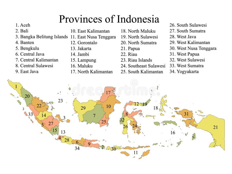
Deneme sürümüyle ücretsiz Map of indonesian provinces pastel colored labeled flat provinces map of asian country of indonesia map of indonesian provinces pastel colored labeled flat provinces map of asian country of indonesia.
Deneme sürümüyle ücretsiz Simgeler içeren Endonezya idari bölgelerinin haritası. Konum pimi, ok, büyüteç, tabela, adam, bisiklet, araba, uçak, ev içeren harita. Telifsiz Endonezya vektör haritası. Endonezya idari bölgelerinin haritası, departmanlar, simgeler. Konum pimi, ok, adam, bisiklet, araba, uçak içeren harita. Simgeler içeren Endonezya idari bölgelerinin haritası. Konum pimi, ok, büyüteç, tabela, adam, bisiklet, araba, uçak, ev içeren harita. Telifsiz Endonezya vektör haritası
Deneme sürümüyle ücretsiz Pulau lepar indonesia cropped to square topo standard in the java sea belonging on a topographic osm style map pulau lepar indonesia cropped to square topo standard in the java sea belonging on a topographic osm style map.
Deneme sürümüyle ücretsiz Pulau laut indonesia highlighted and labelled bilevel in the java sea belonging to described on a elevation map pulau laut indonesia highlighted and labelled bilevel in the java sea belonging to described on a elevation map.
Deneme sürümüyle ücretsiz Pulau raas indonesia highlighted and labelled bilevel in the java sea belonging to described on a elevation map pulau raas indonesia highlighted and labelled bilevel in the java sea belonging to described on a elevation map.
Deneme sürümüyle ücretsiz Pulau bawean indonesia cropped to square topo standard in the java sea belonging on a topographic osm style map pulau bawean indonesia cropped to square topo standard in the java sea belonging on a topographic osm style map.
Deneme sürümüyle ücretsiz Doğu Cava Eyaleti Sembolik Haritası (Endonezya), eyaleti farklı boyutlarda rastgele dağılmış renkli kareler deseniyle gösteriyor. Doğu Cava Eyaleti Haritası (ID). Doğu Cava Eyaleti Sembolik Haritası (Endonezya), eyaleti farklı boyutlarda rastgele dağılmış renkli kareler deseniyle gösteriyor
Deneme sürümüyle ücretsiz Batı Cava Eyaleti'nin (Endonezya) sembolik haritası, eyaleti/ili farklı boyutlardaki rastgele dağılmış renkli karelerle bir desen halinde gösterir. Batı Cava Eyaleti Haritası (ID). Batı Cava Eyaleti'nin (Endonezya) sembolik haritası, eyaleti/ili farklı boyutlardaki rastgele dağılmış renkli karelerle bir desen halinde gösterir
Deneme sürümüyle ücretsiz Doğu Cava Eyaleti Sembolik Haritası (Endonezya). Eyaleti/ili, şekerleme gibi üst üste binen renkli karelerden oluşan bir desenle gösteren soyut bir harita. Doğu Cava Eyaleti Haritası (ID). Doğu Cava Eyaleti Sembolik Haritası (Endonezya). Eyaleti/ili, şekerleme gibi üst üste binen renkli karelerden oluşan bir desenle gösteren soyut bir harita
Deneme sürümüyle ücretsiz Cava Barat Eyaleti Sembol Haritası (Endonezya). Eyaleti/ilı şekerleme gibi üst üste binen renkli karelerden oluşan bir desenle gösteren soyut harita. Cava Barat Eyaleti Haritası (ID). Cava Barat Eyaleti Sembol Haritası (Endonezya). Eyaleti/ilı şekerleme gibi üst üste binen renkli karelerden oluşan bir desenle gösteren soyut harita
Deneme sürümüyle ücretsiz Map of indonesia highly detailed vector illustration indonesia map highly detailed vector illustration map of indonesia highly detailed vector illustration indonesia map highly detailed vector illustration.
 Oturum aç